Tuesday, 28 June 2022

A Section of the Windermere Way Path

Fell Foot Park to the car & passenger ferry across the lake to Bowness. The path takes in Newby Bridge, Lakeside, Finsthwaite, High Dam and the shore line to Ferry House. 13.5miles 1700ft  

Low cloud and early rain forecast followed by some sunshine, was proved to be spot on!

Having got off the bus at Fell Foot I started with a walk round the country park while the rain was still falling. It was a very wet misty scene looking up Windermere.


There was just a hint of the brightness to come looking up the river Leven where it leaves lake Windermere 


The path lead through Staveley-in-Cartmel where I passed Millerbeck light railway. https://www.millerbeck.org.uk/


These rather expensive looking speed boats were moored on the river outside The Swan Hotel Newby Bridge 


Next came Lakeside ferry terminal for the Windermere steamers.


The path then leaves the lakeside and climbs up through Finsthwaite village passing the rather unusual shape of St Peter's church
  

After a futher climb through Finsthwaite heights the attractive High Dam lakes are reached with some interesting reflections.....
 

.....and again


Continuing past the first little tarn.... 


....to High Dam itself


I then continued down the steeply descending path to the Windermere lakeside just in time to see 'Teal', the ferry I saw at Lakeside earlier this morning. 


Continuing along the lakeside passing Rawlinson Nab


It was clearly good weather for sailing on the lake


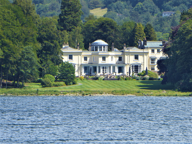
Looking  across the lake to the very luxurious 
Storrs Hall Hotel.....


......from my lunch spot opposite


Just a very small section of an extremely large flock of geese that flew from the field in front of me to the  water


One of the many luxurious boat houses I passed


I arrived at the ferry just in time to cross over to Bowness 


Finally a pleasant walk past the Marina into Bowness


Tuesday, 21 June 2022

 Great End, Allen Crags & Glaramara from Seathwaite

Great End,  Allen Crags & Glaramara from Seathwaite 10.5miles 3700ft ascent including a climb to the first section of the Gable Girdle South Traverse for  reconnaissance purposes only!

Looking down into Borrowdale from the climb to Styhead tarn 


Enjoying the early morning sunshine by the tarn 


The first stage of Gable's south traverse was just a climb up over grassy hillocks, then the crags of Kern Knotts were ahead. I crossed the boulder field to them but confronted with the view (see photo below), taken later in the day from further away, was as far as I ventured.


Kern Knotts are the dark crags towards the bottom right corner. The faint path to Little Hell Gill and the lower part of the Great Napes crags can just be seen rising from the bottom to the top of the photo. With that prospect ahead I retraced my steps to Styhead tarn! 


From Styhead tarn I then headed to Great End


Nearing the top of Great End and looking over Esk Hause to the unmistakable Langdale Pikes


The path leads across Great End summit until the view down to Wasdale Head suddenly opens up 


Broad Crag, Ill Crag and Scafell Pike from Great End summit 2986ft  


After retracing  my steps again over Esk Hause it was just a short climb to Allen Crags summit 2572ft with a first view of Derwentwater 


Lunch time by the side of  a little tarn between Allen Crags and Glaramara


A Panorama shot of Great End, Bow fell & Crinkle Crags


Great Gable, Green Gable & Pillar from Glaramara summit 2569ft


Looking back at a tricky section of the descent off Glaramara


Seathwaite farm, my starting point this morning


Finally looking up to the Styhead Gill my first climb this morning


Thursday, 16 June 2022

A walk to World's End and back home 

in time for tea!

Castell Dinas (Llangollen) to World's End and return to Llangollen via the Offa's Dyke Path. 13.5miles   2550ft

Deserted streets in Llangollen town centre
 as I make an early start for Castell Dinas

     
The river Dee flows through the centre of the town


Castell Dinas is now a ruin of a medieval castle which commands a strategic view point over the valley 


Although only 1050ft high it affords a great view of Llangollen 


I walked round the perimeter of the summit before continuing my walk to World's End


Looking back to Castell Dinas with Llangollen behind 


I  climbed up through the Trevor Rocks.....

....followed by a very gentle climb up Eglwyseg Mountain which according to my map would take me to.....


.....World's End, but what would I find at the 'End of the World',  I wondered?


The answer was clearly not much! 
I decided to at least mark the place with my trusty stick


However it seems that these crags which form part of a wooded gorge that I had just descended through may also be World's End


A little further on it became clear that I was indeed at World's End


I then joined the Offa's Dyke Path which would take me back to Llangollen


It was a wonderful stretch of path which continued for about 2 miles at this height along the escarpment


  Eventually the path descended to the valley floor
 

It was then just a short walk to join the Llangollen canal for the last mile back into the town


 This was a very gentle stroll with much of interest after a somewhat disappointing World's End!!